Want to learn more about GIS?
According to Wikipedia, “A geographic information system (GIS) is a system designed to capture, store, manipulate, analyze, manage, and present all types of geographical data…. In the simplest terms, GIS is the merging of cartography, statistical analysis, and computer science technology.” (Wikipedia, 2013) http://en.wikipedia.org/wiki/Geographic_information_system\
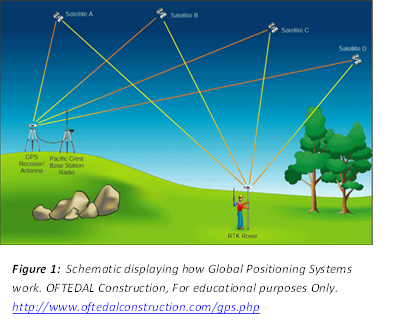
What is GPS? A global positioning system or GPS is often confused with GIS because of their similar sounding acronyms. A GPS is a handheld device that utilizes satellite technology to triangulate the instruments position on the earth. These spaced-based satellites return a signal and allow the calculation of the instruments position on the earth. This position is reported as a pair of coordinates, containing an X (longitude), Y (latitude) and sometimes a Z (elevation) coordinate. Accuracy of the position is dependent on the number of satellites available and the strength of their signal, cloud cover and forest canopy can both reduce strength of satellite signals.
Basic Definitions
As with any discipline, a complete set of specialized terms come along with discussing GIS, in order to make the rest of this document less intimidating, we’ll start with a few basic definitions.
The term “geospatial“ refers to anything that has a geographic location or place on the earth. (EPA, 2012) Most everyone uses geospatial information continually in your daily life, but perhaps not through the context of a computer. However with the recent changes in technology, most internet or smartphone users use geospatial technology on a daily basis through the form of Google Maps, yelp, and other common software program or applications. http://www.epa.gov/geospatial/
Founded in1969, the Environmental Systems Research Institute (Esri) began as a small research group focused on land-use planning. The company’s early mission was to organize and analyze geographic information to help land planners and land resource managers make well-informed environmental decisions. Over the past four decades, Esri has established themselves as the industry leader in geospatial solutions, and holds a large market share of software users in the GIS industry.

“ArcGIS is computer software developed by Esri that is designed for working with maps and geographic information. It is used for: creating and using maps; compiling
geographic data; analyzing mapped information; sharing and discovering geographic information; using maps and geographic information in a range of applications; and managing geographic information in a database.”(Wikipedia, 2013) http://en.wikipedia.org/wiki/ArcGIS
The system provides an infrastructure for making maps and geographic information available throughout an organization, across a community, and openly on the Web.
“The geodatabase is the common data storage and management framework for ArcGIS. It combines “geo” (spatial data) with “database” (data repository) to create a central
data repository for spatial data storage and management.”(Esri, 2012) http://www.esri.com/software/arcgis/geodatabase/
Vector A representation of the world using points, lines, and polygons. Vector models are useful for storing data that has discrete boundaries, such as country borders, land parcels, and streets.
Raster A representation of the world as a surface divided into a regular grid of cells. Raster models are useful for storing data that varies continuously, as in an aerial photograph, a satellite image, a surface of chemical concentrations, or an elevation surface.
A shapefile, is Esri’s proprietary and popular geospatial vector data format for geographic information system software. Shapefiles spatially describe features: points, lines and polygons, representing, for example, water wells, rivers, and lakes. Each item usually has attributes that describe it, such as name or temperature. The shapefile has become the industry standard in storing geographic data and is widely used by all types of GIS software products.
What can GIS do for me?
GIS is used to answer questions that have geographic context. This includes being able to map where things are, map quantities, map densities, map change and finding out what is inside or nearby a certain feature or specifically selected types of features. GIS can lead to better decision making, improved communication, higher efficiency and cost savings.
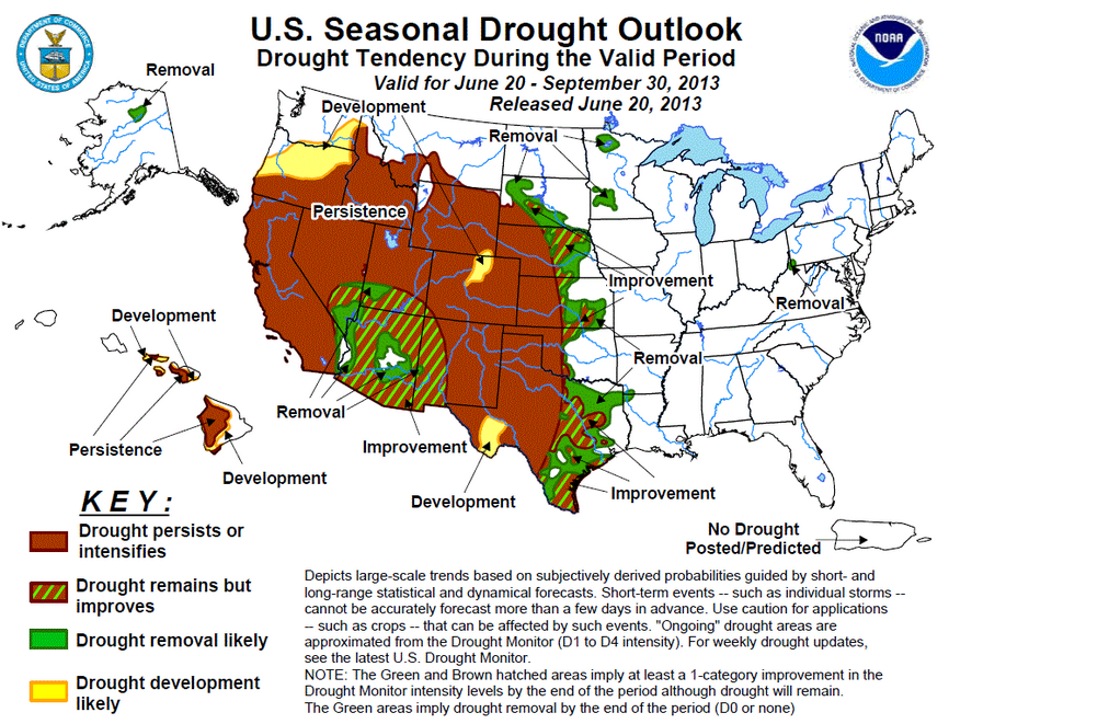
The figure below, maps the US seasonal Drought Outlook using data collected from NOAA and the National Weather Service. Without knowing anything about GIS, one can quickly gain an understanding of the 2013 season’s drought for this summer as the map and it’s Key tell a powerful story. By collecting different types of data and pairing the data with it’s geography one can replicate this same process to create maps that tell your data’s story. This is only one of many examples of how GIS can help you understand and communicate your data.
What’s out there and how do I learn more about GIS?

The first step in learning more about how geographic information can leverage your current data and improve future data collection, it’s best to begin at the beginning. In the following information I’ve aimed to summarize available products and services, what functionality each product may offer, and some links to get you started learning!
Free Open Source Resources
Google Earth
Without a doubt the simplest and most familiar of all mapping software packages come from Google. Most people are familiar with Google maps from their smartPhones or tablets or from simply using google maps to get directions to go somewhere. Less familiar to many is another Google product “Google Earth” that ups the ante when it comes to creating map data. With Google Earth you can create KML or KMZ files that you can email to a GIS professional who can easily integrate your data into their GIS. It’s easy to create points, lines or polygons using Google earth, however editing and querying are not possible.
Download Google Earth
ArcGIS Online
(http://www.arcgis.com/home/index.html)
- Make a map of points using the following file types (GPX, CSV, SHP)
- Share data with others through a web map or app.
- Measure the area, or length of a feature
Check out their Quick Start Guide
http://www.esri.com/library/brochures/pdfs/quick-start-arcgis-online-organizations.pdf
ArcGIS Explorer
(Online and desktop versions, *online recommended until new versions work out some of the bugs in desktop)
- Search for and open maps, and navigate around within a map
- Create new maps, add and edit different types of map content
- Find out more information about the things shown in the map
- Locate places, addresses, airports, intersections, and other geographic entities
- Measure the length and area of things on a map
- Visually interpret data in the map using a dashboard
- Create a presentation to show to other people
- Share your map with other people
- Create and manage data and groups on ArcGIS Online
http://www.arcgis.com/explorer/?open=db678cda21f84047b16e681a002573f4
Quantum GIS
A fully functional GIS platform, analogous to Esri’s ArcMap. (http://www.qgis.org/)
- Perform advanced analysis (manipulate, add, remove, edit data of multiple sources and generate a unique products)
- Perform advanced analyses including georeferencing, and raster analyses.
- Create and provide large amounts of data to your organization, with no upfront software costs!
Quantum GIS (QGIS) is a cross-platform free and open source desktop geographic information systems (GIS) application that provides data viewing, editing, and analysis capabilities. (Wikepedia, 2013)
You can download the software and user guides at the links provided below.
QGIS User Guides http://www.qgis.org/en/documentation/manuals.html
QGIS Software http://hub.qgis.org/projects/quantum-gis/wiki/Download
Other Resources that require payment
ArcGIS for Desktop:
The industry standard for GIS! Advanced analytical tools, and specialized extensions allow for maximum flexibility in spatial analyses. Ability to visualize complex spatial patterns to your data. Fully integrates with ArcGIS Online to publish desktop maps to web. Extensive topical technical forums and training are available (see Training end of this document)
(A 60 day free trial of ArcMap is available, otherwise $$$, non-profit and tribal rates are available for little to no cost)
Free 60 Day Trial
http://www.esri.com/software/arcgis/arcgis-for-desktop/free-trial)
Non-Profit License Application
http://www.esri.com/nonprofit/ela
Learning to use your software
In order to master desktop GIS software, a significant time investment is required. Both ArcGIS/ArcMap and Quantum GIS have thousands and thousands of commands. There is no possible way of being proficient unless you invest a significant amount of your time. However, you can learn rather quickly how to use the basic functionality of the various programs which can yield a tremendous amount of useful information. In order to learn more…please visit our GIS Training Page.